Geospatially heterogeneous and interdependent changes across the globe, such as emergency management, population growth, and rapid urbanization, pose many grand scientific and societal challenges. To tackle these challenges, as a geospatial data deluge permeates broad scientific and societal realms, requires critical thinking about the complex interactions between their driving processes and related geospatial patterns across a number of spatial and temporal scales. Geospatial software plays increasingly important roles in examining such interactions and has been widely developed and used by numerous communities to transform data with geo and spatial references into valuable insights and significant scientific knowledge. The growing benefits and importance of geospatial software to science and engineering are driven by tremendous needs in numerous fields such as agriculture, ecology, emergency management, environmental engineering and sciences, geography and spatial sciences, geosciences, national security, public health, and social sciences, to name just a few, and these are reflected by a massive digital geospatial industry.
In this context, NSF has funded a project to conceptualize a Geospatial Software Institute (GSI) that aims to create bridges across many geospatial domains by establishing a long-term hub of excellence in geospatial software to serve diverse research and education communities. Input from communities of geospatial software users and developers is critical to conceptualizing such an institute. This conceptualization project is engaging such communities, primarily through three workshops and multiple surveys. The first workshop, focused on connecting big data with geospatial discovery and innovation, was held in January 2018 at the University of Southern California. In addition to a group of community leaders who are part of the project team, other attendees were selected via an open call for position papers that were issued to a broad set of mailing lists of diverse science communities and that invited contributions of ideas and opinions on the following topics.
All of the accepted position papers are available online: https://gsi.cigi.illinois.edu/workshop/position-papers/.
Fifty workshop participants representing diverse research and education communities came together to identify a set of key science domains (e.g., biosciences, environmental science and engineering, hydrology, polar sciences, social sciences, and the nexus of food, energy, and water) that a potential GSI could jointly serve to enable convergence research and education. The attendees reached a clear consensus that a potential GSI is urgently needed to:
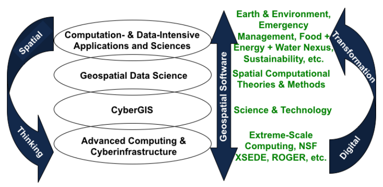
The workshop agenda, presentation slides, and discussion questions are available on the project website: https://gsi.cigi.illinois.edu/workshop/agenda/. At the beginning, the project principal investigator, Shaowen Wang, gave a talk sharing the background and vision of the project as summarized in the following diagram.
Subsequently, in his keynote talk, Mike Goodchild identified two important themes GSI should focus on 1) improving existing software for cutting-edge geospatial computational and data sciences; and 2) leading the community into the next decade. Goodchild emphasized that GSI needs to be long-term and forward-looking, ensuring a vibrant software environment that will help communities overcome major issues and tackle frontier science questions. Nancy Wilkins-Diehr presented the second keynote, providing a successful example of how the science gateway community organized themselves into an institute and what challenges they have resolved and what worked for them. The GSI community should be able to learn from their experiences. Two plenary talks from NSF program directors – Rajiv Ramnath and Daniel Sui – shared the NSF’s Ten Big Ideas and provided insights into how GSI could contribute to advancing big data cyberinfrastructure (CI) ecosystems while tackling science challenges related to multiple of the big ideas.
The workshop held four-panel discussion sessions and three breakout group sessions to provide opportunities for broad and deep discussions among participants. A set of interrelated points, with a particular focus on what GSI should do to address community needs, emerged from these discussions and are summarized as follows.
The workshop attendees have built strong momentum for furthering the conceptualization process. This is an unprecedented opportunity for GSI to enable broad and diverse geospatial scientific communities to revolutionize discovery and innovation through synergistically advancing high-performance geospatial computing, data science, and software.
Copyright © CyberGIS Center. All rights reserved.